National Hydromet Discussion
— National
National
Tropical
Update
For this morning's FHO issuance, the Southwest into the Intermountain West selection was removed due to the overall flooding threat coming to an end as chances for widespread thunderstorms have largely decreased for the region in the short term. The region will continue to be monitored throughout the week for renewed flood threats.
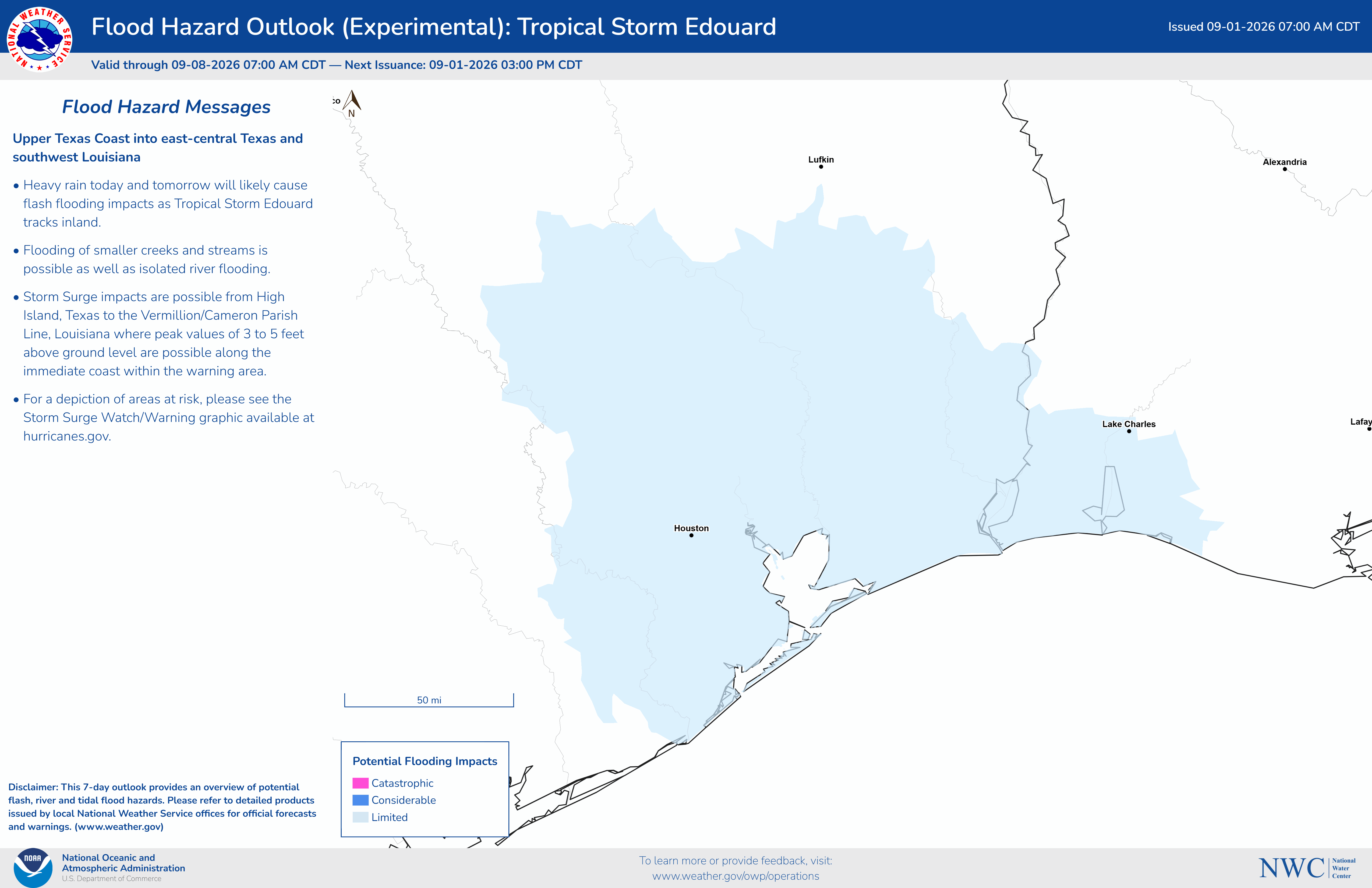
For the Upper Texas Coast into east-central Texas and southwest Louisiana selection, the Days 1 - 7 timing was updated to Days 1 - 3 to better reflect the timing of likely flooding impacts and expanded slightly on the northwestern extent to account for changes in QPF.
The Northeast Days 1 - 7 Limited selection was also modified to a Days 1 - 3 Limited to better reflect the timing of the isolated flooding impacts possible in the short term.
Previous discussion as follows:
...Monsoonal moisture brings flash flooding in the Southwest into the Intermountain West through tonight...Flash and urban flooding in the Northeast... Tropical Depression Five in the Upper Texas Coast into Southwest Louisiana...
Southwest into the Intermountain West
Flash flooding from widespread scattered convection will continue to be possible through at least this evening across much of Arizona and Utah, especially in arroyos, canyons, dry washes, and areas in and around burn scars. As much of this region contains complex terrain, the current storm system will also have the potential for locally significant flash flooding, which as the storm pushes into the overnight hours will also make for a particularly hazardous situation. Following a brief dry period beginning tomorrow, another set of storms is forecast to move over this area late this week which could renew the risk for flash flooding. However, as the system is later in the forecast period in addition to current inconsistencies in model guidance, we will not address it in the current Flood Hazard Outlook, but will continue to track these storms as we get further into the week.
Northeast
Flash, urban, and small stream flooding is possible through the next several days as a convective system moves through the region. While this weekends model runs lacked consistency in placement and magnitude of this systems precipitation, there seems to be greater agreement between todays model runs, increasing confidence in the possibility for impacts. Of particular concern will be the many urban centers in the region, where the risk of flooding will be greatest if sustained or intense rainfall rates occur. Outside of urbanized areas, while the regions soils are generally normal and will be able to initially mitigate flooding concerns, consecutive days of rain will increase the risk of saturating soils and subsequent surface runoff, possibly leading to flood impacts. However, current storm tracks suggest that these storms could be fairly progressive, which may help limit flood risk.
Upper Texas Coast into east-central Texas and southwest Louisiana
Flash, urban, and minor to isolated moderate river flooding will be possible from the upper Texas Coast into Southeast Texas, particularly portions of the Houston Metro area, and into Southwest Louisiana beginning late tonight through Wednesday morning. Heavy rainfall from Tropical Depression Five will bring 3 - 5" of rainfall with local amounts of 6 - 9", increasing the chances of flash flooding particularly in urbanized locations and areas prone to flooding. Isolated river flooding may also be possible in portions of Southeast Texas starting in the middle of the week.
000
AGUS74 KWCO 011159
HMDNWC

National Hydrologic Discussion - EXPERIMENTAL
NWS National Water Center - Tuscaloosa AL
700 AM CDT TUE SEP 1 2026

.Update...

For this morning's FHO issuance, the Southwest into the Intermountain West
selection was removed due to the overall flooding threat coming to an end
as chances for widespread thunderstorms have largely decreased for the
region in the short term. The region will continue to be monitored
throughout the week for renewed flood threats.

For the Upper Texas Coast into east-central Texas and southwest Louisiana
selection, the Days 1 - 7 timing was updated to Days 1 - 3 to better
reflect the timing of likely flooding impacts and expanded slightly on the
northwestern extent to account for changes in QPF.

The Northeast Days 1 - 7 Limited selection was also modified to a Days 1 -
3 Limited to better reflect the timing of the isolated flooding impacts
possible in the short term.

//EAS / JEC

Previous discussion as follows:

...Monsoonal moisture brings flash flooding in the Southwest into the
Intermountain West through tonight...Flash and urban flooding in the
Northeast... Tropical Depression Five in the Upper Texas Coast into
Southwest Louisiana...

.Southwest into the Intermountain West...
Flash flooding from widespread scattered convection will continue to be
possible through at least this evening across much of Arizona and Utah,
especially in arroyos, canyons, dry washes, and areas in and around burn
scars. As much of this region contains complex terrain, the current storm
system will also have the potential for locally significant flash flooding,
which as the storm pushes into the overnight hours will also make for a
particularly hazardous situation. Following a brief dry period beginning
tomorrow, another set of storms is forecast to move over this area late
this week which could renew the risk for flash flooding. However, as the
system is later in the forecast period in addition to current
inconsistencies in model guidance, we will not address it in the current
Flood Hazard Outlook, but will continue to track these storms as we get
further into the week.

.Northeast...
Flash, urban, and small stream flooding is possible through the next
several days as a convective system moves through the region. While this
weekends model runs lacked consistency in placement and magnitude of this
systems precipitation, there seems to be greater agreement between todays
model runs, increasing confidence in the possibility for impacts. Of
particular concern will be the many urban centers in the region, where the
risk of flooding will be greatest if sustained or intense rainfall rates
occur. Outside of urbanized areas, while the regions soils are generally
normal and will be able to initially mitigate flooding concerns,
consecutive days of rain will increase the risk of saturating soils and
subsequent surface runoff, possibly leading to flood impacts. However,
current storm tracks suggest that these storms could be fairly progressive,
which may help limit flood risk.

.Upper Texas Coast into east-central Texas and southwest Louisiana...
Flash, urban, and minor to isolated moderate river flooding will be
possible from the upper Texas Coast into Southeast Texas, particularly
portions of the Houston Metro area, and into Southwest Louisiana beginning
late tonight through Wednesday morning. Heavy rainfall from Tropical
Depression Five will bring 3 - 5" of rainfall with local amounts of 6 - 9",
increasing the chances of flash flooding particularly in urbanized
locations and areas prone to flooding. Isolated river flooding may also be
possible in portions of Southeast Texas starting in the middle of the week.

//Cordak/Ducre

Additional National Water Center products are available at
www.weather.gov/owp/operations


$$